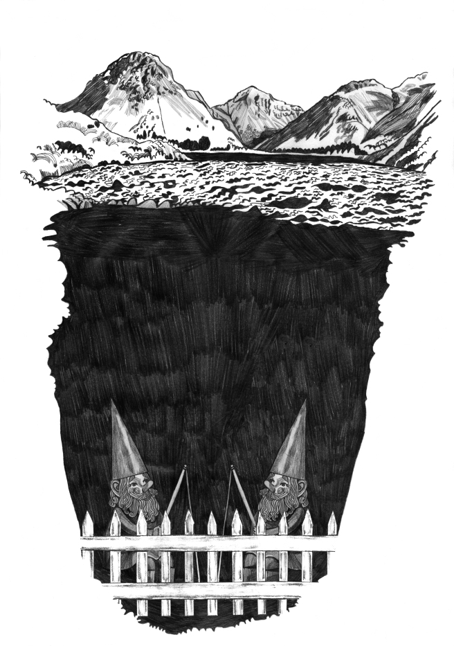
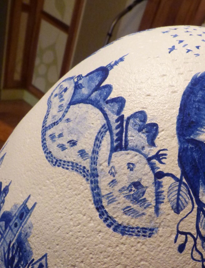
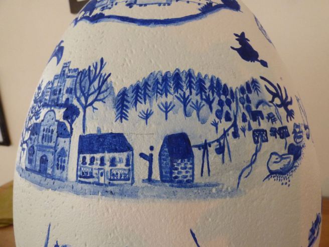
It was my great delight this Easter to take part in The Big Beautiful Egg Hunt in Lancaster. Artists were invited to transform giant eggs into works of art in Aid of Cancer Care.


The name Lancaster refers to a Roman fort which stood by The River Lune and was once where Lancaster Castle now is. Walking up from The Millennium Bridge towards the castle there’s evidence of this in the remains of a bathhouse on the left.


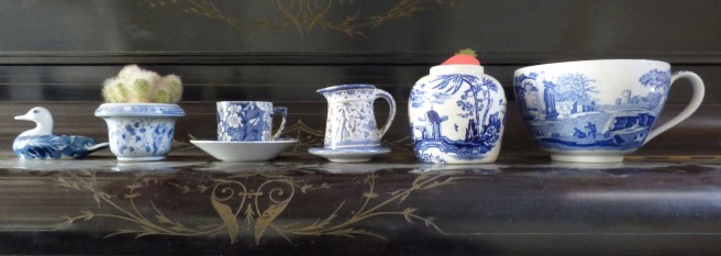
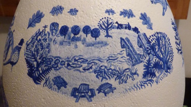
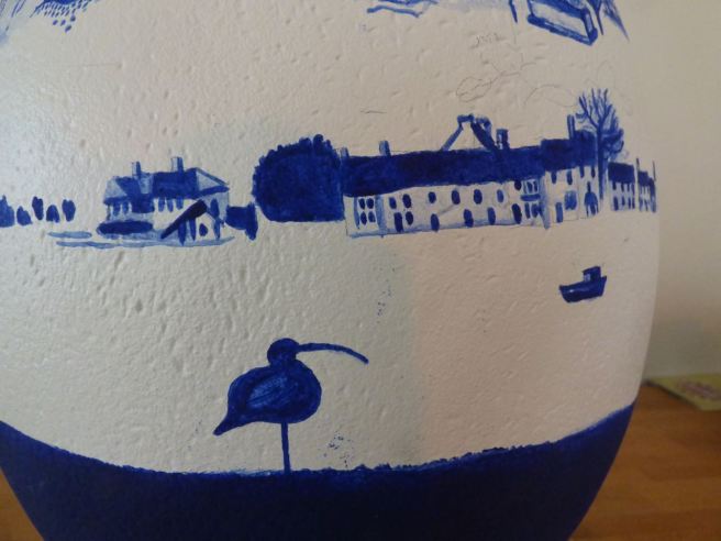
I thought it would be interesting to chart the journey the river makes from source to mouth. Thinking about the shape of the egg, it occurred to me that it was a slightly fatter version of a vase. My house has an array of Spode plates and blue and white ceramics, which in turn inspired my idea to record the Lune through a series of picturesque scenes using only blue on a white background.


Here is my story of the River Lune. In reality I did it in reverse, reaching Ravenstonedale in the looming dusk. For clarity I’ll recall it back to front and the correct direction that the river flows!


At Ravenstonedale- a village near the source of the Lune I saw my very first red squirrel and thus ticked one of my life missions off the list! It’s a cute little village with a church, primary school, golf course, play park, gallery and pub, complete with beer garden. Towers of pine trees wall either side and a great many beech trees litter the ground with their seed. A stream flows through the village which I’d earlier mistaken for the Lune…it is actually Scandal Beck, which is later joined by Stone Gill and flows North East past Soulby to eventually join the River Eden.
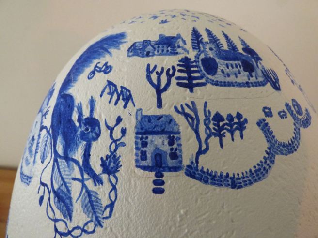
North West is Newbiggin-on-Lune, a small hamlet, but part of the greater parish of Ravenstonedale. Here springs gather in St Helen’s Well, the source of the River Lune. At the centre of the hamlet I chanced upon a gaggle of geese. As dusk approached murmurations of starlings flitted around the skyline and the wind pummelled all insight.


Heading west neighbouring springs filter into the Lune and around Tebay the river meets with train tracks and the M6. They course through the valley banked dramatically by the hills of The Yorkshire Dales on the East and The Lake District on the West. The village of Tebay overlooks from one side and the A685 (my route) climbs out from the other.
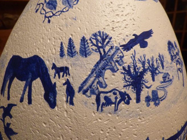
The steep slopes carry into wilder moorland; hardened cows and sheep, gorse and hawthorn, leant into the landscape, while stiff tufts of grass dance with the whims of the wind. Here it seems the weather is too wearing for hedgerows and drystone walls divide the fells willy nilly; abandoned buildings sit in remembrance of a time passed. Meanwhile the Lune, winds in the valley beneath, flowing under disused viaducts, past plentiful farms, sheep, cattle and horses.


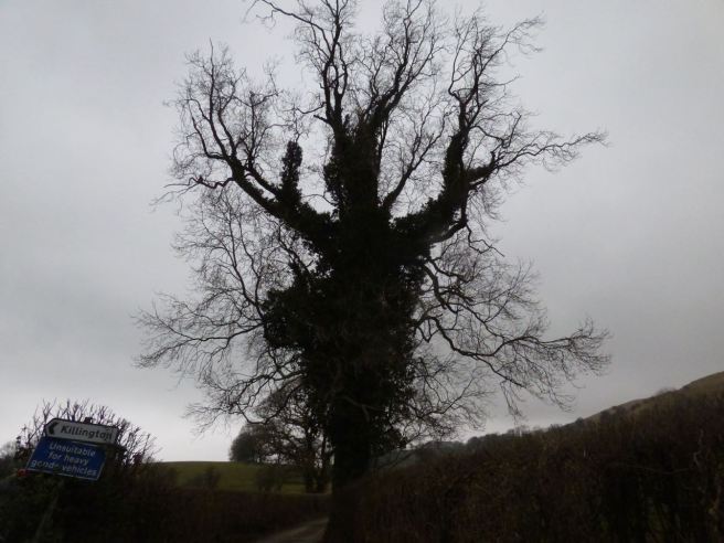
Here hills climb and fall. There’s a sense the air is fresher (though fragrant with manure) evident in the surrounding growth, laden with moss and lichen. The vegetation is more varied; deciduous oak and birch; and evergreen firs, holly and ivy. Old trees, overgrown with ivy, cut imposing silhouettes against the sky; a murder of crows flies by.
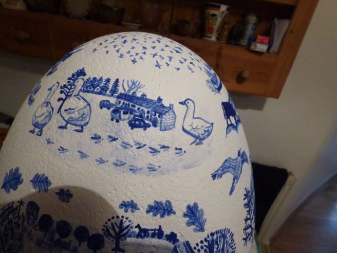
Between Firbank and Killington the landscape starts to even out, the steepness lessening into a gradual rolling. While still progressing through The Yorkshire Dales, all evidence of this is to the East; distant mountains creating a spectacular backdrop. The Lune and I experience flatter terrain, fields upon fields of farmland; lambs nuzzling into their mothers, a number of stationary tractors. There’s a huge, solitary monkey puzzle tree in the centre of one field, but otherwise the trees are largely more deciduous, in particular oak.
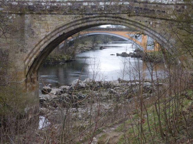
There’s two golf courses on the approach to Kirkby Lonsdale, the latter surrounded by pillars of puffy pines. A pheasant, nonchalantly spectates my progress. At the town, I park up and walk along the river from Devil’s Bridge to Radical Steps. The bridge was built in 1370 and is evidently a famous viewing spot as a great many benches and picnic tables are set around it. According to legend the Devil appeared to an old woman and promised to build a bridge as long as he could claim the first soul that crossed it. Once completed, the woman outsmarted the Devil by first enticing her dog over it with a bit of bread. Next to Devil’s is Stanley Bridge which was built in the 1930’s to accommodate greater traffic needs. It is a grade 1 listed structure and a Scheduled Ancient Monument. It is also, to my eye, very beautiful.


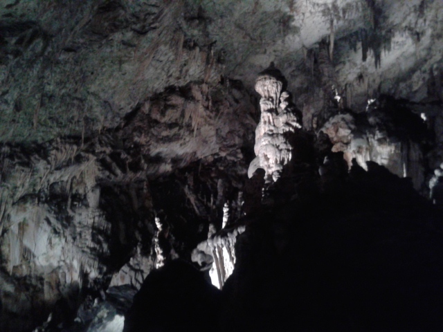
This stretch of the Lune is broken by a great many limestone formations; massaged and moulded into their present shape by the incessant rhythm of the river. On a pebbled beach, a couple of trees, cut down to the root appear like giant, hairy spiders. I reach Radical Steps, steep steps constructed in the 1820’s which climb up to the Church and Ruskin’s view. A plaque informs me the Lune is famous for salmon and trout and in turn that the viewpoint was made famous, initially by Turner, who painted it in 1822, and latterly by John Ruskin, in 1875, who described his picture:
as one of the loveliest scenes in England.
As we continue on the landscape is revealed forth as largely flat. On occasion there are small wooded areas but for the most part it is fields of sheep, dotted with deciduous tress, predominantly oak.


Hornby is a very pretty village East of the Lune. The River Wenning flows through the centre, joining up with the Lune just downstream. The village has its own castle and many grand buildings besides. Walking through I notice curious/ amusing/ intricate little details.


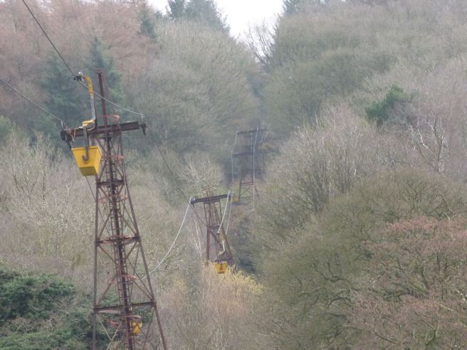
Onwards, we pass by Cloughton. Beautiful doe-eyed cows look out from a barn. Stacked hay bales reach great heights in an adjoining field. Most notable is Cloughton Manor Brick Works. Built in 1898, it is the last aerial ropeway in Britain. It was shut down for a few years during a house building slump, but now, thanks to some refurbishments and greater demand, it is up and running again.
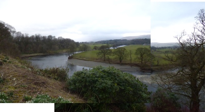
At the Crook o’Lune; as the name suggests, the river does a hair pinned bend back on itself. It’s an extremely beautiful picnic site, tree-lined and rural and part of The Pendle Witch Trail. Two of the bridges, passing consecutively over the river, are part of an old railway line, and head back to Lancaster. Popular with cyclists and walkers, the way is strewn with snowdrops and wild garlic. Below, on a pebbled beach, a flock of ducks take in forty winks.


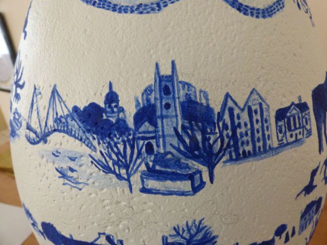
Into the city itself and over The Millennium Bridge. Its spires reach up high and in the haze of the day their blue tinge mirrors the cap of the Ashton Memorial in the distance. Daffodil and crocus line the grassy verge and black-headed gulls bob on the surface of the water.


Walking up to the castle I pass the Roman Bath House on the left. At the top, the church looks out at the river to one side and a mini amphitheatre staggers down the hill. Between the two, atop a tombstone, lies a headless lady; still elegant and all the more alluring to me for what she lacks. The church and the castle back on to one another.
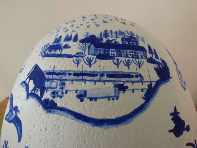
Back by St George’s Quay I walk alongside the river. Old warehouses line the way, their timber hoists still intact. Many of the buildings date back to the mid 1700’s when the place was quite an active port. Overtime, the river gradually silted up and Glasson Dock took over. Rather fittingly the Maritime Museum is now housed in the old Custom House. It was also designed by Richard Gillow, son of the furniture maker Robert Gillow, both renowned Lancastrians.


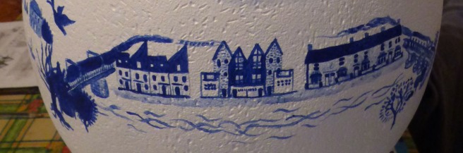
Passing under the railway bridge there’s been much recent development, in the rows of modern housing- their sleek exteriors cut rather differently to Luneside Cottages- a cute row of old terraced homes at the end of the road. The way narrows into a cycle way that continues on to Glasson Dock. At this point I get my geography mixed up, expecting this section of the Lune to meet with the aqueduct further downstream. It has actually already done so, shortly after passing under the M6 on the initial approach into the city. For the purposes of composition however, it is quite convenient: mirroring the railway bridge and providing a frame for the above image!
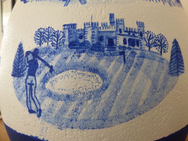
As the Lune nears a curve it passes by Lancaster Golf Club- Ashton Hall and the surrounding land banking the river. A Grade 1 Listed mansion, it was originally built in the 14th Century and is now a popular venue owned by the Golf Club.
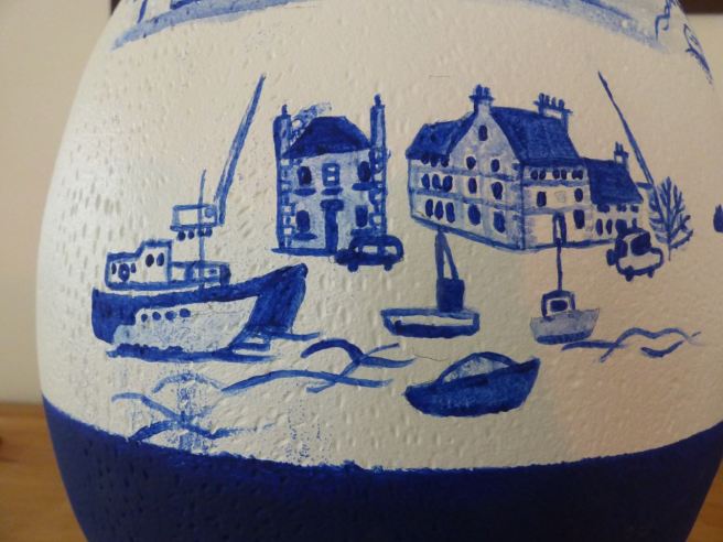
The Lune’s breadth increases as it comes into Glasson Dock. Originally a small farming and fishing community, the late 1700’s saw it become the largest port in the North West when it became too difficult to navigate further upstream to the city. These days, it’s a much quieter marina- the rigging of the moorings ringing with the turn of the breeze.
The mouth of the river meets Sunderland Point and the Lune escapes into the sea. Sunderland, a small hamlet is set among marshland and becomes cut off from the mainland at high tide; its literal meaning being ‘the land that is sundered from the main’. Robert Lawson, a Quaker, developed it into an outport for Lancaster in the early 1700’s but eventually Glasson Dock became the preferred port. The marshes are a great habitat for birdlife and I passed by a curlew on my visit.
So there we have it: the story of the Lune through my own experience. It was a full day of driving, note-taking, sightseeing and photography. I enjoyed it immensely and was struck by the variation in landscape and wildlife as the Lune grew. I think we forget sometimes about the bigger picture- that something or, indeed, someone is not just that section or snippet that we see but a whole collection of different experiences that make a whole. I’m sure I’ve barely scratched the surface, but what I have uncovered has been worthwhile. I’ve learnt a bit, and grown a bit and I painted my egg with something that means something to Lancaster, but, now, also to me.